
Welcome to Aysén, the northernmost region of the southern half of Chilean Patagonia, an astounding place of primeval beauty.
I will be introducing you to five parks in this area alone, and I dare say you can’t afford to miss a single one, as each will leave you with indelible images and memories that will inspire you to write books of your own!
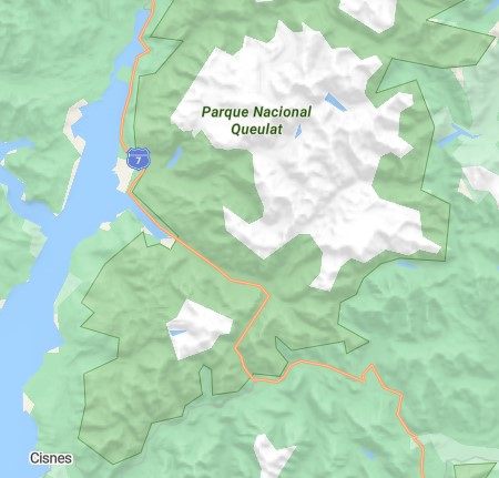
The first park on our list is Queulat, which has a history steeped in myths and is sought out for its epic waterfalls and a glacier hanging off a cliff. Others combine a hiking trip to Queulat with a visit to the famed Puyuhuapi hot springs nearby.
If you haven’t yet read up on some of the foundations of the entire seventeen-park route, go back and check out my overview post so you can get oriented.
This is also the first park in the series that you can get to from north, west, and south; by ferry, bus, or private hire. You can even plan to get here crossing in from Argentina without much trouble at a all.
Because Queulat is so centrally located geographically, “closest” is relative to where you’re coming from originally.
If you’re following this park series of articles, and going in the order presented, then the airport you will have gone through already is Puerto Montt.
However, if you’re starting your journey with this park, then you would be better to fly to Balmaceda. This is the airport that serves Coyhaique, Chile, which is closer to Queulat.
Chaitén also has a small regional airport that you could fly to from either Puerto Montt or Balmaceda, but keep in mind you have to go through some extra legwork to negotiate flights there that would probably take long enough that you can get there faster by bus.
The fee for us adult foreigners is currently 9,000 chilean pesos, which is approximatey $10 USD. Youth get a 50% discount, and children under 12 years old there is no charge.
Pets are not allowed.
For this park, they require reservations and entrance fees be paid in advance online at https://aspticket.cl. You will then get a code you can show to park rangers on your phone.
Camping fees are additional at 10,000 CLP ($11 USD) per person, which can be paid on site at the Ventequero campgrounds or the Angostura grounds.
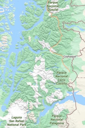
Coyhaique is the provincial capital and geographic center of the Aysén region, but it only makes sense to start there if you’re flying in to Balmaceda airport, as you’ll have to travel north from there to get to Queluat and then return the way you came to get to all the other parks in Aysén.
What more people do is travel by bus from Chaitén going south to Puyuhuapi, which is the town that is surrounded by Queluat, and about equidistant a bus trip as that from Coyhaique. Bus travelers can then get off the bus at the three main access points into the park around Puyuhuapi.
But, for those who are hiking this series with me, none of the above applies as you because you will have just had your epic hiking on the archipelago of Chiloé and thus are going to start at the ferry dock either in Castro or Quellon, and go by ferry across the Corcovado Gulf and Moraleda canal to Puerto Cisnes, from where you can then take a shorter land route by bus or private shuttle up to Puyuhuapi.

Open all year
Topography: Temperate Rainforest
Climate: Cold, no dry season.
Long before it was a tourist destination, Queluat was steeped in legend as the hiding place for Trapalanda, a city wedged in an Andean valley between a mountain of gold and another mountain of diamonds. Jesuit priests were the last to come looking for it in 1766, so you can imagine as you walk the trails, how they might have been wondering if the next bend in the trail would suddenly reveal the elusive “city of Caesars” as they called it.
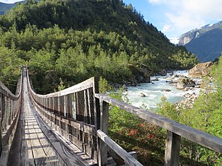
No such city was ever found, but Queluat’s wealth is its opulent scenery, with high cascading falls and the iconic hanging glacier of Ventisquero, beautiful and dramatic suspended wooden bridges crossing deep chasms, and trails that are all easy to medium rated hikes in terms of difficulty.
Queluat is of special interest to conservationists and biologists because it provides some unique protective habitat for several species, including black woodpecker, condor, chucao, pudú, güiña, puma and the four-eyed toad. In terms of flora, it stands out for the protection of Patagonian Andean forests, made up of species such as lenga, dwarf maitén, white michay and Magellan coigue; and in the evergreen forests and peat bogs, the Chiloé coigue, tepa, tineo, chilco and canelo.
Lodging is conveniently pocketed around the park in Puyuhuapi, which is also home to the famous hot springs bearing the same name, as well as charming small towns like Villa Amengual, El Carmen, and Puerto Cisnes where you also take the ferry to other parts of Patagonia.
Puyuhuapi was settled by German immigrants, so you will encounter customs, traditions, names, and dialect that are intermingled with Chilean culture. In this vein, the area is known for its own artesanal beer, Hopperdietzel, you should make a point to try.
|
Name
|
Distance
|
Hiking Time (round-trip)
|
Difficulty
|
Features
|
Open
|
|---|---|---|---|---|---|
|
Los Pumas
|
2.9 km
|
6 hours
|
Medium
|
Los Pumas Lagoon
|
All year
|
|
Mirador del Ventisquero
|
3.8 km
|
2 hours
|
Medium
|
view of the glacier from above
|
All year
|
|
Laguna Témpanos
|
1.1 km
|
40 minutes
|
Easy
|
foot bridge, glacier view, lagoon boat trips
|
All year
|
|
Mirador Panorámico
|
400 m
|
20 minutes
|
Easy
|
glacier and rivers viewpoint
|
All year
|
|
Aluvión
|
325 m
|
30 minutes
|
Easy
|
bird watching
|
All year
|
|
Salto Padre García
|
325 m
|
30 minutes
|
Easy
|
waterfall
|
All year
|
The distance between the northernmost trailhead and southernmost trailhead is 64 km, so about an hour to get from choices top to bottom. Most of the trails noted above in the Trail Guide are pretty short, so it’s possible you can do at least two trails in a day, even if you’re relying on a passing bus. You could do even more if you hire a private driver to shuttle you around on a day-trip plan where they can wait for you in the parking lot of each hike.
It’s best to plan to lodge in Puyuhuapi, because innkeepers there will make it really easy to find a local driver to bring you to the hiking trails and back to the inn by supper time, and all trails are equally less than 30 minutes away.
Another good alternative if you are more interested in the popular southern trails is to lodge in Puerto Cisnes, as the southern trailheads range from 30 to 45 minutes away from there, and innkeepers there can also find a local driver to bring you there and back. The advantage of this option is you can more easily use the ferry system to come in and out of the area and visit the next park in our series, Isla Magdalena.
The third strategy is to come down through the park area on a bus from Chaitén going toward Coyhaique (or Puerto Cisnes). This is about a 3-hour trip to the closest trailhead (5 hours to the farthest) and only operating on Tuesdays, Thursdays, and Saturdays at 10 a.m., so the bus would drop you off at your desired trailhead after noon, which isn’t ideal for starting a hike. Plus, there won’t be a passing bus to get you into town probably for a couple days, so you would be wise to plan this carefully with your inkeeper in case they have an offer to pick you up from your hike to bring you to their lodging.
Ferries also only come in and out of Puerto Cisnes (from Quellon, and to Puerto Chacabuco) a couple times per week, but planning around them is easier as their schedules are fixed and you can reserve them online.
The famous Route 7 is also called Carretera Austral, and it is the scenic highway into Patagonia. For bus travel, you can order reservations online from Chaiten to Puyuhuapi. These operate only on Tuesdays, Thursdays, and Saturdays, departing Chaiten at 10 a.m. and arriving to Puyuhuapi around 1 p.m.
In Puyuhuapi, there’s just a bus stop on the main road through town, and you buy tickets in the Nido de Puyes market on the corner next to the stop.
The ferry to Puerto Cisnes from Quellon is something you can reserve in advance online. It’s comfortable, accessible, and has departures at 18:00 (6 pm) on Tuesdays and Thursdays, and Saturdays at 17:00 (5 p.m.). This is a twelve-hour trip, so you arrive in Puerto Cisnes between 5 and 6 am.
It is also the option you will be doing if you’re following the full park series I’ve documented.
Buses from Puerto Cisnes going north to Chaitén and through Puyuhuapi are provided by the only bus company in town, which is Terraustral. They are located at the southern edge of town in a converted residential house with an office in front and a wooden sign with their name. Just ask any resident as you walk into town, it’s s small village and they will point you the way. They do not post schedules, so you will either need to consult them with them after you arrive, or request us to contact them and provide a research report based on your itinerary.
You also have the option of hiring a driver from Puerto Cisnes or Puyuhuapi to take you to various trailheads for the day and bring you back. The best way to do this is directly through your lodging in one of these villages, as they will know the local private transport options and might be able to include that service in their overall package.
The clear winner in my estimation is to base yourself in Puerto Cisnes. While Puyuhuapi is more central to Queulat, you can always add the hotsprings as a side trip after one of the hikes and return to Puerto Cisnes all in the same day.
Puerto Cisnes has the unique advantage of getting there by ferry, which is by far the most enjoyable of the transportation options. Plus, Puerto Cisnes doubles as a hub to private kayak and public ferry excursions to the neighboring park that can only be accessed by water, which is Park Isla Magdalena, so you can reach out to two parks from one place.
The only downside is the public and private land transportation availability is a bit more limited, but not by much. All you have to do to overcome that is ask your innkeepers for their assistance in that respect, and they will be more than willing to make it work, because in the end, it’s in their self-interest for your whole trip to be successful.
South America Buses (SAB) is the luxury channel of AndesTransit, the land travel transportation schedule and reservation hub preferred most by travelers to Latin America. SAB has a select team of distinguished travel experts who have dedicated themselves to research, document, and curate routes and carriers in South America that meet nothing short of the highest quality standards in land travel.
Other Links
Copyright © 2024 SouthAmericaBuses. All rights reserved.